It all began on Saturday, June 23rd...I sit enjoying a good book on my deck, look up after a break in the chapters, and see this:
Oh no, not another fire in Colorado...our drought conditions, triple digit temps and winds make for perfect conditions...unfortunately! Colorado, at this time, had 8 major fires burning, this fire was #9. It was named the Waldo Canyon Fire, and soon would become the most destructive fire in Colorado history! Mandatory evacuations were set in place for areas along the fire line.
By Monday, it looked like this:
On Tuesday, I had a different aspect of the fire from the south end of Colorado Springs, however, I had no idea what I was in for. On my commute home, I experienced something I have never experienced before, and hope I never do again.
Here's how my commute started out, I didn't realize what I was looking at. Later, I learned, this is called a pyrocumulonimbus cloud...the combination of fire and smoke with features similar to a severe thunderstorm.
Here's what I encountered during the rush hour (the following pictures were taken while traffic was stopped...safety first!). It was like driving into a severe thunderstorm, but this is smoke! It looked like it was snowing, and it was...snowing ashes!
This picture, looking west towards the fire:
The sun glowing behind all the smoke, near Garden of the Gods exit from I-25:
You can't even imagine the air quality on my (80 minute) commute home...with air conditioning in my car on recirculate, my eyes burning, my throat scratchy and sore.
Finally, I'm home. I took this picture from my deck. The sun looked like a red ball of fire in the sky.
I tuned into the news when I got home, and later found out some horrifying news. As I was making my commute home, hundreds of people were loosing their homes to this devastating fire (I have seen pictures of neighborhoods burning, but chose not to show them here...they are just too depressing). The winds shifted (as they often do), and we experienced sustained 60+mph winds for the better part of an hour. The Waldo Canyon fire had turned into a "firestorm of epic proportions" right before the eyes of everyone tuned into watching the afternoon news briefing about the fire. I was glued to the media for the next several hours, as I watched my city go up in flames.
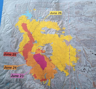
Here's a progression map of the fire from the day it started on Saturday (June 23), to the devastation that occurred on Tuesday evening (June 26). The fire had tripled in size in less than 24 hours, with up to 32,000 people evacuated from their homes.


No comments:
Post a Comment